Monday, September 2, 2013

Driving Cross Country (미국 대륙횡단) - California Death Valley (켈리포니아 데스벨리)

오늘은 죽음의 계곡이라 불리우는 데스 밸리(Death Valley)를 구경하고 켈리포니아에 있는 요세미티 공원 (Yosemite National Park)으로 갈 예정입니다. We plan to travel to Yosemite National Park after stops in Death Valley.

데스 밸리는 라스 베가스에서 차로 약 3시간 거리이지만 여름에는 데스벨리 낮 온도가 화씨 110 도가 넘는다하여 아침부터 움직일 생각으로 데스 밸리 서쪽 입구 근처인 아마고스 밸리 (Amargosa Valley)에서 전날 밤 묵었습니다.
Even though t is about 3 hour drive to Death Valley from Las Vegas, we decided to stay overnight at Amargosa Valley which is one of entrances to the valley from the west. We figured we would have early start staying close to the valley since the temperature at Death Valley in summer could be higher than 110 degree.

데스 벨리 (죽음의 계곡)는 과장해서 지은 이름이 아니고 실제로 서부 개척 시대에 부를 찾아 서부로 가던 많은 사람들이 물도 없고 더운 이곳에서 죽었습니다. 그래서 붙은 이름이 데스 벨리 입니다. 한 때는 8500 피트 지점까지 물에 덮여 있던 호수 였으나 지금은 물이 말라 사방이 높은 산으로 둘러싸여 있는 황량한 사막입니다.  가장 높은 봉우리는 해발 1만 1049 피트이고 가장 낮은 바닥은 바다 수면 보다 낮은 -282 피트(-86 미터) 입니다.

Death Valley is not exaggeration. It is called Death Valley because many people traveling to the west looking for the wealth died here with lack of water and extreme heat. It was once a lake where it was filled with up to 8500 ft, but it is now a bleak desert surrounded by high mountains. While the highest peak is 11,049 ft, the lowest point is 282 ft below sea level.

사진으로 보고, 듣고하여 별로 큰기대 없이 그저 덥고 사막지대를 볼 것이라는 생각으로 데스벨리를 들어섰습니다. 그러나 데스 밸리는 너무나 많은 것을 보여 주었습니다. Since we heard about Death Valley and have seen them in pictures, we entered the valley not expecting much except that we would see a lot of the desert. However, it had many surprises and was well worth a visit.


Death Valley Map/데스 밸리 지도

데스밸리 구간으로 진입하니 주변의 색갈들이 신비스럽기도하네요.
As we approached the valley, the colors of surrounding area gave the mysterious feeling.


지옥의 상징 (단테즈 뷰, Dante's View)

1.7 Km 높이에 "지옥의 상징"이라고 불리우는 단테의 뷰 (Dante's View)는 용광로 개울 (훠나스 크릭, Furnace Creek) 지역 전체를 볼수 있는 전망대이다. 단테즈 뷰는 데스 밸리에서 사진 찍기에 가장 좋은 곳 중에 한 곳입니다. 아래 하얗게  보이는 것은 "나쁜 물 유역 (Badwater Basin)"에 있는 소금 밭입니다. 이곳에서 미국 본토에서 알라스카를 빼고 가장 높은 지점과 가장 낮은 지점을 모두 볼 수 있습니다.

Dante's View is an overlook located at 5500 ft high and you can see the whole area of Furnace Creek. It is one of the great photographic spots in Death Valley. The white area on the left of picture is Badwater Basin and it is covered with salt. You can also see the highest point and lowest point on the United States except Alaska.

From Dante;s View/지옥의 상징에서 내려다 보며
On the Road to Dante's View/단테즈 뷰로 가는 길에서


자브리스키 포인트 (Zabriskie Point)

호수 바닥에 깔아 앉었던 세미토와 화산 재가 지진으로 솟아오르며 가끔 내리는 소낙비로인해 오늘의 신기하고 아름다운 이 모습이 되었다고 합니다.
Fine silt and volcanic ash deposited at the bottom of lake was uplifted and the periodic rainstorm caused the strangely beautiful landscape today.

Zabriskie Point/자브리스키 포인트
자브리스키 포인트 (Zabriskie Point)에서 용광로 개울 (Furnace Creek)으로 가는 길에서...
On the road to Furnace Creek from Zabriskie Point...


골든 협곡 (Golden Canyon)

훠나스 크릭에서 "나쁜 물 유역 (Badwater Basin)" 을 향해 남쪽으로 가다보면 골든 협곡 입구가 왼쪽에 있습니다.  골든 협곡 은 2 마일 정도의 트레일 코스이다. 전에는 자동차로 갈 수 있었는데 한 번의 홍수로 길이 막혔다고 합니다. 너무 늦어 질 것 같아 얼마간 걷다가 되돌아 왔음.

Heading south to Badwater Basin from Furnace Creek, the entrance to Golden Canyon is on left. There is a 2-mile trail into the canyon. Until some time ago, you were able to drive into the canyon, but it was blocked after one severe flooding. We cut it short of our trailing due to the time constrain.

Golden Canyon Entrance/골든 협곡 입구
Golden Canyon/골든 협곡

악마의 골프 코스 (Devil's Golf Course)

이 곳은 실제 골프를 할 수 있는 곳이 아니고 악마들만이 이런 곳에서 골프를 칠 것이라고 지어진 이름입니다. 포장 되지 않은 길을 따라 밸리 중간 까지 들어 갈 수 있고 소금 위를 걸어 볼 수 있습니다. 땅이 굉장히 울퉁불퉁한 것이 걷기에 약간 힘들 수 있습니다.
You can not play the gold here, but it was named as Devil's Golf course because only the devils play the golf on this land. You can drive into the valley following the unpaved road and walk on the salt. The surface is very uneven and walking could be a little difficult.

Devi's Golf Course/악마의 골프 코스

나쁜 물 유역 (베드 워터 베이신, Badwater Basin)

훠나스 크릭 (Furnace Creek) 에서 유일하게 물이 있는곳이다. 그러나 염분 농도가 바닷물보다도 높아 마실 수 있는 것은 아닙니다. 먹을 수 없는 물이라고 "나쁜 물"이라고 불리기 시작했다. 하얗게 펼쳐진 이곳은 꼭 눈이 쌓인 곳처럼 보이지만 소금 밭이다.

This is only place where the water exists, but it is not drinkable since the salt concentration is higher than sea water. Hence, it is called Badwater Basin. The white field looks like snow, but it is covered with the salt.

해발 -86 미터로 북미에서 가장 낮은 곳입니다 (세계에서 가장 낮은 곳인 사해는 해발 -414 미터 입니다) It is the lowest point in North America at 282 ft below sea level (Dead Sea which is lowest in the world is -1360 ft).

Badwater Basin/나쁜 물 유역
오후 12시 반 경인데 벌써 화씨 100도를 가르키네요. The thermometer already indicates 100 degree at 12:30 in the afternoon.


염전 위로 걸어 들어 갈 수 있습니다. 꼭 하얀 고은 모래 위를 걷는 것 같이. You can walk out to the salt pan. It feels like you are walking on very fine white sand.

Path on the salt pan/염전에 나 있는 길
오직 이 곳에서만 볼 수 있던 물 (마실 수는 없지만)과 초록색 나무들이 있네요. This is only place we found water (even though undrinkable) and green trees.


Artist Drive

화가의 길 (Artist Drive)은 길이 15.5 Km 의 포장된 일반 통행길인데 형형 색색의 암석들이 놓여 있어 색다른 느낌을 주는 지형이다. 땅 속에 있던 여러 가지의 금속 성분이 노출되면서 발하는 색갈들이다.
The 9 mile paved road of Artist Drive is one-way and it is surrounded with multiple colors and textures in the rock. As the different ingredients of metal are exposed, they emit different colors.


훠나스 크릭 인 (Furnace Creek Inn & Ranch )

데스 밸리 한 가운데에 있는 훠나스 크릭 인 (Furnace Creek Inn & Ranch )입니다. 야자수와 어울려져 있는 모습이 꼭 사막의 오아시스를 보는 기분이네요. 이 곳에 머물면 데스 밸리를 구경하기는 편하지만 그대신 숙박료는 싸지 않습니다. 그러나 가끔 자신을 위해 쓰는 것도 괜찮지 않을까요.
Furnace Creek Inn & Ranch is conveniently located in the middle of Death Valley.  The inn together with palm trees in the middle of nowhere reminds us an oasis in the desert. If you stay at the inn, it would be convenient to tour the valley, but it could be pricey depending on the season. However, you may want to treat yourself.

Furnace Creek Inn & Ranch/훠나스 크릭 인


메스키트 플렛 모래 언덕 (Mesquite Flat Sand Dunes)

스토브파이프 웰 근처에 있는 이 모래 언덕은 제일 잘 알려져 있고 방문하기에 쉬운 곳입니다. 이 모래 언덕은 제일 높은 것이 30 미터 밖에 안되지만 광대한 면적을 차지하고 있습니다. 모래 언덕이 생길려면 필요한 것이 바람인 것 처럼 모래 회오리 바람이 모래 언덕을 넘어가네요.
It is the best known and easiest to visit and located near Stovepipe Wells. Although the highest dune rises only 100 feet, the dunes actually cover a vast area. One of elements needed for the dunes to exist is the wind and the sand whirlwind was blowing across the dunes.

Mesquite Flat Sand Dunes/메스키트 필렛 모래 언덕
Sand Whirlwind/모래 회오리 바람


데스벨리를 벗어나자마자 초록색이 보이는 것이 환경이 전적으로 바뀌네요.
As soon as we were off Death Valley, the surrounding changes completely with greens.


이상한 바위 형성 모습.  Strange rock formation.


후기 (Epilogue)

일출과 일몰 때 사진이 정말 멋지다고하는데 전날밤 늦게 호텔에 도착해 아침 새벽에 일어나기가 힘들어 저희는 기회가 없었습니다.
It is known that the sun rise and sun set are the best time for photo opportunity. Because of our late arrival the night before, getting up before the dawn for the photo opportunity was just too much for us.

가끔 다른 방문객들을 만나기도하지만 아무 것도 없으면서도 아름다운 곳을 경험하기는 처음 이었습니다. 다른 절기에 다시 한번 찾아 오고 싶은 곳입니다. 사진으로는 이 땅의 모든 색갈들을 진정으로 경험할 수가 없네요. 직접 실물을 보시기 바랍니다.
Even though we cam across other visitors in the valley, a place of beauty while empty was a different, but amazing experience. We are hoping to visit the valley during different season. The pictures do not justify the colors of the land. You have to experience them yourself.

이곳을 방문할 떄 주의할 것은 아침과 낮의 온도 차이가 심할 수 있다는 것을 기억하시고 준비하십시오. 그리고 간식과 특히 물을 중분히 준비하시고 변소는 들릴 기회있을 때 들리십시오. 마지막으로 자동차 연료는 들어가기 전에 만 탕크하시고요. 훠나스 크릭 (Furnace Creek)에 있는 주유소가 연료를 가장 비싸게 파는 것으로 나쁜 소문이 나있는데 사실은 데스 밸리 들어가기 전에 있는 주유소들이 50전은 더 비싼 연료를 팔드군요.
If you plan to visit Death Valley, there are few things to prepare. Prepare layered cloth since the temperature change is quite large between morning and afternoon. Also, prepare snacks and especially a lot of water. Use the bathroom facility whenever you have the chance and fill up your gas tank. The gas station at Furnace Creek has a bad reputation as selling the highest priced gas in the area, but other gas stations near to the entrances to park are selling the gas 50 cent higher.


Badwater Ultramarathon

데스 밸리를 구경하려 다니면서 자주 그 더운 길을 뛰는 사람들을 보곤했습니다. 제정신으론 이런 짓을 안 할것이기에 무슨 모금 수집을 위한 것인가 생각하며 다니다 한 보조 팀을 만나 이것 저것 이야기를 나눌 시간이 있었습니다. 이 뛰는 사람들은 주최측에 따르면 "세상에서 가장 힘든 경기"인 울트라 마라톤에 참가한 사람들이라고 합니다. 그것도 7월 제일 날씨가 더울 때에. 그런데 이 마라톤에 아무나 참가할 수 있는 것이 아니고 초대를 받아야만 참가 할 수 있다고 합니다. 원래는 미국에서 제일 높은 곳인 휘트니 정상 (높이 4.4 Km)과 제일 낮은 곳 나쁜 물 유역 (베드워터 베이진, -86 m)을 잊는 235 Km 거리였지만 허가 문제로 휘트니 포탈 까지인 217 Km로 단축했다고 합니다.

While touring Death Valley, we came across number of people who were running in the hot weather. We thought it was some kind of fund raiser since nobody in right mind would do it. We had a chance to have a small talk with one of support team and the runners are in the Badwater Ultramarathon. It is described itself as "the world's toughest foot race" and takes place in mid-July when the weather conditions are extreme. Furthermore, it is an invitation only event. Originally, the run was 146 mile course between the lowest and highest points in the contiguous United States, Badwater Basin, Death Valley (-282 ft) and Mt Whitney's summit (14,505 ft). Because of permit issue, it is shortened to 135 miles to Whitney Portal.


일본인 보호소 (Japanese Detention Center)

하이웨이 99번을 타고 요세미티 공원으로 가다 뜻하지 않게 2차 대전시 세워졌던 일본인 보호소에 들렸습니다. 이제는 고고학자들의 연구 대상지이지만 남은 건물들이 그 때를 상상케 합니다.
On the way to Yosemite Park, we unexpectedly came across Japanese Detention Center which was built at the beginning of world war II. It is now the site of archaeologist's study, but the guard tower and buildings made us to imagine the desolate situation.


Longstreet Inn & Casino
4400 S Highway 373
Amargosa Valley, NV 889020

방은 넓었고 깨꿋했습니다만 불을 다 켜놓아도 어두운 편이었습니다. 그러나 하루 밤 쉬고 가기에는 문제가 없었습니다. 한가지 다른 점은 카지노와 함께 하는 호텔인데 체크인 카운터가 일찍 문닫는 것이었습니다.
The room was large and clean, but the room was a little dark even with all the lights on. It was good enough to rest one night. It is strange as a casino, but the front desk closes early for the hotel check-in.


내일은 요세미티 국립공원을 구경하고 샌프란시스코로 향하는 일정입니다. Tomorrow we will be heading to San Francisco after touring the Yosemite National Park.


Saturday, August 24, 2013

Driving Cross Country (미국 대륙횡단) - Nevada/Arizona Hoover Dam (네바다/아리조나 후버 댐)

네바다/아리조나 경계에 있는 후버 댐. Nevada/Arizona Hoover Dam

아리조나 세도나를 떠나 켈리포니아 데스 벨리로 가는 길에 네바다와 아리조나 경계에 있는 후버 댐 (공식적으론 네바다 임) 들렸습니다. 후버 댐은 경제 공황 당시 5년 안에 완공 되었습니다. 수천명의 일꾼들이 불렉 케년으로 들어와 그 당시 제일 큰 댐을 싸았습니다. 미국 토목 공학 협회에서 이 댐을 현대 토목 공학 7대 불가사의 중에 하나로 뽑았습니다.

방문 시간: 9 시 - 6 시, 안내소와 발전소 관광: 8불-11불
주차장: 네바다 쪽 안내소 건너편 케년에 있는 주차장 (7불). 댐에 가까운 아리조나 쪽 주차장 (7블)과 조금 더 떨어진 4개의 주차장 (공짜)
안내소 출입과 차로 댐을 건낼 때는 보안 검사를 받아야만 합니다.

After leaving Sedona, AZ, we stopped at the Hoover Dam on the way to Death Valley in California. Hoover Dam was built in less than five years during the Depression. Thousand men came to Black Canyon and built the largest dam of its time. It has been rated as one of America's Seven Modern Civil Engineering Wonders by the American Society of Civil Engineers.

Visitor Center: 9 AM - 6 PM, $8 - $11 for Visitor center and power plant tour
Parking: In Nevada side, the parking garage across from the visitor center into a canyon ($7). The parking lot closest to the dam in Arizona ($7) and the other 4 lots further into Arizona (free).
It is required to go through the security check before crossing the dam by car and entering the visitor center.


호수 쪽으로 있는 흡입 타워를 통해 183 미터 높이로 떨어지는 물의 압력으로 4개의 터빈을 돌려 생기는 전력의 반은 라스 베가스에 공급됩니다. 지금까지 한번도 누수 사고가 없었다고 합니다.    Four concrete intake towers on the lake side drop the water down about 600 feet to drive turbines and the half of generated electricity is supplied to Las Vegas. There was never any water leak.

Intake Tower/흡입 타워
댐의 높이는 221 미터, 넓이는 220 미터 입니다. 위에서 내려다보면 아찔합니다. 60층 건물에서 내려다 보는 것과 비슷하니깐요.
The dam is 726 ft in height and 721 ft in width. It makes you dizzy looking down the dam. It is similar to looking down from 60-story skyscraper.


댐의 한쪽은 아리조나이고 다른 쪽은 네바다 입니다. 아리조나는 일광 절약 시간을 안지키기에 두 시계가 같은 시간을 가리키고 있네요.
The state line crosses the middle of dam: one side is Arizona and the other is Nevada. Two clocks show the same time since Arizona does not keep the summer time.

Arizona Side of Dam/댐의 아리조나 쪽
Nevada Side of Dam/댐의 네바다 쪽
밧줄 하나에 의지해서 수 백 미터 높은 협곡에 매달려 공사를 하는 "하이 스켈일러" 동상은 "하이 스켈일러" 카페 근처에 있습니다.
The statue of the high scaler who worked hanging by a rope hundred feet in the air on the side of a deep canyon is near the High Scaler cafe.

Statue of High Scaler
후버 댐 사망자 기념비 (Memorial to Hoover Dam Dead) 는 공사 중에 죽은 96명을 기억하며 세워졌스며 기념비에는 "사막의 부흥을 위해 그들은 생명을 받쳤다" 고 새겨져 있습니다.
The memorial to Hoover Dam Dead is constructed to remember the 96 men who died during the construction. The inscription on the memorial says that "They died to make the desert bloom".

Memorial to Hoover Dam Dead/후보 댐 공사중 사망한 자를 위한 기념비
"공화국의 날개 달린 상징"라는 기념비는 43 미터 높이의 깃대를 9 미터 높이의 날개 달린 상징물이 양측으로 감싸고 있습니다. 주 조각가인 오스카 헨센에 의하면 이 기념비는 "변치 않는 지적 결의, 훈련된 육체적 내구력과 과학적 성취의 승리"를 표현한다고 합니다.

The monument called "Winged Figures of Republic" is a 142-foot flagpole flanked by two 30-foot high winged figures. According to the principal sculptor Oskar Hansen, it expresses "the immutable calm of intellectual resolution, and the enormous power of trained physical strength, equally enthroned in placid triumph of scientific accomplishment".

Winged Figures of Republic
후보 댐에서 미드 호수 로 연결되는 수로. The canal leading to the Mead Lake from Hoover Dam.


후버 댐으로 가는 길 도중에 전망대로 가는 길이 왼쪽에 있습니다. 약간 경사진 길을 올라가면 넓은 주차장이 나옵니다. 이곳에서 보이는 미드 호수의 경치는 훌륭하고 멋있는 사진을 찍을 기회가 주어집니다.
On the way to Hoover Dam, there is an overlook on the left side. There is a big parking lot on the top when you drive up a slight hill. The view of Lake Mead is worth for the drive and it provides the opportunity for the wonderful photographs. The nation's largest reservoir is experiencing a severe drop-off in water levels and it could impact the life of Las Vegas.

Lake Mead/미드 호수
해가 기울기 시작하여 저희들은 올라가지 않았지만 후버 댐 우회 다리에서 보는 댐의 조망이 일품이라고 합니다. 이 다리는 서반구에서 제일 높고, 긴 아치 모양의 콩크리트 다리입니다.
Since the sun started to go down, we did not go up to the Hoover Dam bypass bridge. But we heard that the bridge provides a commanding view of the Dam. It is the highest and longest arched concrete bridge in the Western Hemisphere.


라스베가스는 올 봄에 들린적이 있어 이번에는 저녁만 먹고 지나가기로 하였습니다. 관심이 있으시다면:
We decided to stop at Las Vegas only to eat the dinner since we visited Las Vegas earlier this year. If you are interested:

Las Vegas Trip (라스베가스 여행기) .


Ma Dang
953 E Sahara Ave Las Vegas NV 89104

인터넷에서 보고 가는 길에 있기에 찾아간 곳은 이조 곰탕 (나중에 평을 보니 않가기 잘한 둣 하지만)인데 찾지를 못하고 가까운 곳에 진미장 (Gin Mee Jang) 과 마당(Ma Dang)이 있었습니다. 진미장은 고기구이 집인데 고기 구이를 먹을 정도의 배는 아니고 마당 앞에 차가 더 많이 주차되어 있어  마당에서 저녁을 하였습니다. 오래간만에 먹은 한식인 돌솥 비빔밥과 오징어 볶음 ($36 세금, 팁 포함) 이었지만 잘하는 음식은 아니였습니다. 가는 길이 바쁘다하니 아주머니께서 친절하게 빨리 빨리 해주시긴 했지만.

We were initially looking for Yi-Zo Gom-Tang which we found on the yellow page, but instead we found Gin Mee Jang and Ma Dang. When we saw the review of Yi-Zo Gom-Tang later, it probably was better that we couldn't find it. We decided to try Ma Dang since Gin Mee Jang is BBQ house and we weren't that hungry. Also, there were more cars parked in front of Ma Dang than other restaurants. Even though we were having BiBimBap and stir-fried squid ($36 w tax and tip) in many days, they were just good enough to satisfy the appetite for Korean food. However, knowing we were in hurry, they were very kind and prepared our food quickly.


View Larger Map

아홉째날 운전한 거리. The distance we made in the ninth day of our trip.

내일은 데스벨리를 구경하고 요세미티 국립공원에 도착하는 일정입니다. We will be heading to Yosemite National Park with the stop at the Death valley tomorrow.

다음 여행 기록은 데스 밸리 입니다. Next travel entry is Death Valley.
Driving Cross Country (미국 대륙횡단) - California Death Valley (켈리포니아 데스벨리)


Monday, August 19, 2013

Driving Cross Country (미국 대륙횡단) - Places in Arizona (아리조나 이곳 저곳)


아리조나를 지나면서 중간 중간 찍은 사진들 입니다.
The pictures we took here and there while traveling through Arizona

뉴 멕시코 (New Mexico)에서 유타에 있는 모뉴멘트 벨리 (Monument Valley)로 가는 길에 아리조나 (Arizona)를 지나가며 엣날 서부 영화에서 본 장면들이 생각나 한 컽했습니다. While we were passing through Arizona on the way to the Monument Valley, UT from New Mexico, we took the pictures remembering the scenes from old western movies.


Horse Shoe Band (호스 슈 벤드)

아리조나 페이지에서 고속 도로 89번을 따라 남쪽으로 가다 대자연이 만든 묘기에 잠시 들려 구경하세요. 글렌 케년 댐에서 흘러온 콜로라도 강이 말 발굽 모양으로 흐른다하여 이름 지어진 호스 슈 벤드 (Horse Shoe Bend)이다. 주차장에서 1.2 Km 를 걸어가야 하는데 가파른 오르막 길, 내리막 길 경사와 고운 모래길이 힘들 수도 있습니다. 멀리서 보면 평평한 땅에 있는 계곡 같지만 벼랑 끝에서 아래를 내려다 보면 등골이 써늘해 지기도 합니다. 주차장에서 걸어 들어 가는 길이 멀지는 않지만 고운 모래길이라 약간 힘들 수도 있습니다. 무모한 용기를 가진 아이들과 함께 한다면 각별히 조심하십시오.

You can make a quick side trip to another of Mother Nature's trick off highway 89 south of Page, AZ.Horse Shoe Bend of Glen Canyon is called since Colorado River flows like horse shoe. Ir is 0.75 mile hike from the parking lot, but the trail extracts some effort from you with some steep ups and downs and some deep sand. From afar, it looks like a valley with flat top, but it is a spine-chilling drop from the edge of canyon. Please be careful with kids who dares.


Horse Shoe Bend/호스 슈 벤드


Cameron Trading Post

그렌드 케년 동쪽 입구 국도 89번 상에 있는 카메론 교역소 (Cameron Trading Post) 는 흥미 있는 휴게소 입니다. 파는 물건들은 싸구려 기념품부터 아름다우나 꽤나 비싼 나바호 인디언 미술품까지 있습니다. 어떤 여행객들에겐 멈춰 볼만한 가치가 있겠으나 저희들에겐 꼭 잡화범에 들린 것 같은 분위기였습니다.

Cameron Trading Post is an interesting place to stop on highway 89 which is located near the east entrance to Grand Canyon. Their inventory varies from cheap souvenir to beautiful, but expensive Navajo arts. It could be worth the stop for some, but it was more of being at the general store for us.


Pull Out on Highway 93

아리조나 훌렉스테프에서 고속도로 93번을 따라 후버 댐으로 가다 쉴 곳이 있어 들렸는데 생각지 않게 보이는 경치가 좋았습니다.
We stopped at the pull-out on Highway 93 on the way to Hoover Dam from Flagstaff and the scene was an unexpected surprise.

중간에 흐르는 강은 콜로라도 강 입니다. Colorado River is flowing through in the middle of picture.


Sunday, August 18, 2013

Driving Cross Country (미국 대륙횡단) - Arizona Sedona (아리조나 세도나)

아리조나 세도나 (Sedona, AZ)

오크 크릭 케년 경관도로 (Oak Creek Canyon Scenic Road)
훌렉스태프 (Flagstaff)에서 세도나 (Sedona)까지 아리조나 국도 89A 를 따라가는 45 Km 의 구불구불한 길은 옆으로 오크 크릭 (Oak Creek)이 흐르고 숲으로 덮여져있는 소문난 아름다운 길 입니다. USA 투데이 신문은 이 길을 미국에서 가장 경치가 좋은 길로 선정 하였습니다. 신이 그랜드 케년은 모든 사람들을 위해 만들었지만 오크 크릭 케년 (Oak Creek Canyon)은 신 자신을 위해 만들었다고도 합니다. (A 28 mile winding road along AZ 89A to Sedona from Flagstaff is a famous scenic road. The road is covered with trees and Oak Creek flows next to the road. USA Today rated the route the most scenic in America. It was said that God created the Grand Canyon for the the world, but Oak Creek Canyon for himself.)


세도나 (Sedona)

세도나 시는 붉은 바위 (red rock)들과 밤의 경관을 위해 바깥 조명불들도 제한을 할 뿐아니라 2층 이상 집을 지을 수 없으며 집의 바깥 색도 바위 색갈에 맞추어야 합니다. 오죽하면 그 유명한 맥도날드 금색 아치도 이곳에서는 청록색으로 칠해졌을까요.
For the red rock view, Sedona has limited exterior lights for starry nights, no buildings over two stories and everything must match the primary colors found in the rocks including the teal, not gold arches of McDonald.

City Sign and Surroundings Blend Together/시 표시판과 주변 경치가 어울리네요
세도나 보텍스 (땅의 에너지가 소용돌이 처럼 올라 온다고하여)는 땅의 기가 올라와 기도, 명상, 치유에 적합하다하여 지어진 이름입니다. 땅의 에너지가 내적 자아와 상호 작용한다고하는데 유감스랍게도 저희들은 경험하지를 못했네요. 세도나 지역은 60 개가 넘는 영화 촬영장이였고 너무나 볼 곳이 많은 지역이라 하루에 가장 많이 들릴 수 있도록 계획하였습니다.

Since there are so many places to visit in Sedona which is featured in over 60 films, our plan in Sedona is to see as much as we can in a day. The vortexes of Sedona are named because they are believed to be spiritual locations where the energy is right to facilitate prayer, meditation and healing. This energy suppose to interact with a person's inner self, but unfortunately, we have not experienced.

Bell Rock (종 바위)

이곳의 가장 상징적인 종 모양의 벨 롹은 세도나에 있는 4 개의 보택스 중에서도 가장 기운이 강한 곳으로 알려져 있습니다. 두 개의 쉬운 트레일이 있는데 이 트레일을 따라 걸으면 기를 느낄 수 있다고 합니다.

The Bell Rock which is shaped like a bell is the most symbolic place of Sedona. It is also one of 4 vortexes with the strongest energy. There are two trails around the Bell Rock and it was said that you may experience an electrical charge throughout your body while hiking along the trail.

Bell Rock/종 바위
종 바위 (Bell Rock)로 가는 길에서 본 대 성당 바위 (Cathedral Rock). The Cathedral Rock seen from the trail to Bell Rock.

Cathedral Rock/대 성당 바위

The Chapel of Holy Cross (성 십자가 교회)

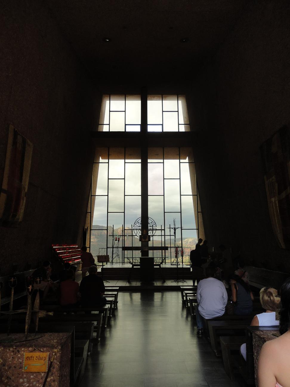
이 305 미터 암벽에 솟아난 63 미터 높이의 독특한 건물은 처음 현대식 건축 양식으로 지어진 케톨릭 교회인데 세도나 근방 수 마일 부근에서 볼 수 있습니다. 1956년 준공 후 교회에서 보이는 바위 언덕과 계곡 경치는 놀랄만하며 많은 방문자들이 이곳에서 평온과 평화를 느낀다고 합니다. 방문 시간은 아침 9시부터 저녁 5시 까지 입니다.

This unique structure is the first contemporary structure built as a Catholic Church and is seen from miles around Sedona. It is 250 ft high and emerges from a 1000 foot wall. Since the completion in 1956, the view of buttes and valleys from the chapel is breathtaking and many visitors say that they are filled with a feeling of serenity and peace here. The hours are from 9 AM to 5 PM.

The Chapel of the Holy Cross/홀리 크로스 기도실


Panorama View from the Chapel/기도실에서 보이는 전경
View from Inside of Church/교회 안에서 본 전경
교회로 올라 가는 길 옆에 핀 선인장 꽃. The cactus flower on the road to the chapel.


Airport Mesa (공항 메사)

공항 길에 있는 4 개의 보택스 중 하나인 공항 메사 (Airport Mesa) 에서는 세도나 계곡의 360도 전망을 볼 수 있습니다.
Airport Mesa is one of the four vortexes and can be reached via Airport Road. It allows 360 degree views of the valley.

View from Airport Mesa/공황 메사에서 보이는 경치

빨간 바위 순환 도로 (Red Rock Loop Road)

세도나 변두리에 있는 빨간 바위 순환 도로 (Red Rock Loop Road)는 빨간 바위 주 공원 (Red Rock State Park)과 레드 롹 크로싱 (Red Rock Crossing)으로 가는 또 하나의 경치 좋은 길입니다. 입구를 놓치는 바람에 아리조나에서 가장 사진을 많이 찍는 레드 롹 크로싱에서 사진 촬영의 기회를 놓쳤습니다.

Red Rock Loop Road on the western outskirt of Sedona is another scenic drive with red rock country's vista with the access to Red Rock Crossing and Red Rock State Park. We missed the road to Red Rock State Park and the photo opportunity at Red Rock Crossing which is most photographed spot in Arizona.


The Views Inn Sedona
65 East Cortez Drive Sedona, AZ 86351

세도나 시에서는 약간 떨어져 있고 유럽식 아침 식사 (continental breakfast)는 별로 였지만 방도 깨끗했고 아침에 방에서 보이는 경치는 일품이었습니다.
The hotel is located few miles south from Sedona and the continental breakfast is nothing special, but the room was clean and the view from the room was great.

View from Hotel Room/호텔 방에서 보이는 전경


Sedona Restaurant (세도나 식당들):

Minami Sushi (미니미 스시)
6586 Hwy 179 Sedona AZ 86351
(928) 284-0684

이 식당은 조그마한 식당인데 스시는 가장 스시답게 제대로 만들드군요 그러나 가격 (2인 분에 40불)에 비해 질이 약간 떨어졌습니다.
This is a small place, and sushi is made close to the way it should be made. But the quality was not what it could be for the price ($40 for two).


Red Rock Cafe
100 Verde Valley School road Sedona AZ 86351
(928) 284-1441

시간을 절약하기 위해 점심은 테이크 아우트을 해서 후버 댐으로 가는 길에 먹기로 하였습니다. 로스트 비후 (8불 29전)와 참치 살라드 (9불 99전) 샌드위치를 주문했습니다. 가는 길에 배는 고프고, 한 입 먹은 샌드위치가 어떻게 맛 있었든지 샌드위치 사진 찍는 것 까지 잊어버렸습니다. 꼭 추천합니다.
We decided to order the take-out and have the lunch on the way to Hoover Dam to save the time. We ordered the Roast Beef and Cheese sandwich ($8.29) and Tuna Salad sandwich ($9.99). Because we were hungry and the first bite of the sandwich was so tasteful, we forgot to take the picture of the food. We strongly recommend this place.


Desert Flour Bakery
6446 Hwy 179 Sedona AZ 86351

세도나를 구경하다 잠시 쉴겸 들렸는데 아주 잘 했던 것 같읍니다. 파이와 빵들이 정말 훌륭했습니다. 그렇게 달지도 않으면서 맛 있었습니다. 꼭 들려 보세요.
We stopped at the bakery for the coffee during the morning sightseeing. It was one of best things we did in Sedona. Pie and pastry were really good. They were not sweet, but very tasteful.


다음 방문지는 네바다에 있는 후버 댐입니다. Our next stop is Hoover Dam, NV.  Driving Cross Country (미국 대륙횡단) - Nevada/Arizona Hoover Dam (네바다/아리조나 후버 댐)


Thursday, July 18, 2013

Driving Cross Country (미국 대륙횡단) - Arizona Antelope Canyon (아리조나 엔텔로프 케년)

엔틸롭 캐년, 아리조나/Antelope Canyon, Arizona

모뉴멘트 벨리를 떠나 다음에 들린 곳이 아리조나 국도 98번 가에 있는 엔틸롭 캐년 입니다. 아리조나 페이지 에서 동쪽으로 6.5 Km 떨어진 곳입니다. (After leaving Monument Valley, our next stop is Antelope Canyon off AZ 98. It is 4 miles east from Page, AZ.)

아주 적은 양의 비가 와도 이 곳은 워낙 좁아 순식간에 물이 차 올라 온다고 합니다. 오래 전에 홍수로 인명 피해가 있은 후 나바호 인디안 가이드 하에서만 관광이 가능합니다. 가이드와 함께 상 엔틸롭 캐년 (Upper Antelope Canyon)과 하 엔틸롭 캐년 (Lower Antelope Canyon) 관광이 가능합니다. 두 캐년을 구경한 관람객 대부분이 둘 중에 하나만을 택해야 한다면 하 엔틸롭 캐년 구경을 추천하여 저희들은 하 엔틸롭 캐년을 택했습니다. 도착한 시간이 정오 때라 상 엔틸롭 캐년 입장료도 1.5배를 달라고도하고요.

Even after a small amount rain, the water comes up very fast in the canyon. Since some of tourist lost their lives after a flood, the sightseeing is only allowed with Navajo tour guide. The guided tours of upper and lower Antelope Canyon are allowed. Most comment by the tourist who visited both canyon indicated that the lower canyon is better if we have to choose one. Another factor was 1.5 times of regular entrance fee for noon tour.

적색 사암의 아름다운 색갈 변화는 아마 가장 많은 사진 소재가 되어 왔습니다. 햇살이 캐년 위에서 부터 둘어와 암석에 비취일 때 암석의 모든 색의 색상이 보여집니다. 또한 캐년의 매끈한 표면에 물과 바람으로 만들어진 파도 모양을 볼 수 있습니다. 프로 사진사들이 찍은 사진이 아무리 아름답다고해도 그 아름다움을 보여 줄 수 없습니다.  그 경외감을 겪어 보기위해서는 본인 직접 보시기 바랍니다.

Gorgeous color gradation of red sandstone is the subject of most photographed. As the sunlight streams into the canyon from the top, the color of the rock show all their hues as the light falls on the illuminated rocks. The rocks also shows the waves left on the smooth surface of canyon. Photographs, as beautiful as some of them are, don't do Antelope Canyon justice. It's a must see for everyone to really experience the awe.

가이드 관광은 일반 관광과 특별 관광이 있습니다. 일반 관광은 방문객이 많아 사람 없이 배경 찍기가 무척 힘들니다. 다음 그룹이 따라오니 가이드는 재촉도하고. 그렇다고 사진사 전용 특별 관광은 좋은 사진기 없이 비싼 요금 내기가 아깝고...

There are two guided tour: general tour and Special tour. During the general tour, it is very difficult to take the canyon pictures without the tourist getting into picture because of crowd and the guide hurrying the tourist for the next tour group. But, then, the fee for photography tour seems to steep without a very good camera.


Upper Antelope Canyon

나바호는 케년의 이 부분을 "빅한니리니" 또는 "바위 사이로 흐르는 물의 장소"로 부릅니다. 또한 관광 코스가 평평하여 가장 많은 방문객들이 들리는 곳이기도 하고요. 11시에서 2시 까지의황금 시간대는 입장료가 어른 40불이고, 다른 시간대는 26불 입니다.
The Navajo refer to this portion of the canyon as The Bighanilini or "the place where water runs through rock." This is the most visited section of the canyon since it is more flat path. The fee during the prime time (11 AM - 2 PM) is $40/adult, otherwise, it is $26/adult.


Lower Antelope Canyon

나선형 암석 아치란 뜻의 "Hasdeztwazi"가 하 엔텔롭 캐년의 이름 입니다. 이 구간은 더 길고 좁을 뿐 아니라 쇠 난간을 오르고 내려야 합니다. 그렇지만 굉장히 아름다운 지질 형성을 볼 수 있다는 것이 헛된 수고는 아닐 것 입니다. 입장료는 26불 입니다 ( 전에는 더 저렴했는데 하 엔틸롭 캐년을 찾는 관광객 수가 늘면서 가격을 올렸다고 하네요).
Hasdeztwazi, meaning "spiral rock arches", is the name of the lower portion of Antelope Canyon. This section requires to traverse longer and narrow sections as well as climbing the metal staircases. It is well worth the effort as the lower canyon offers a glimpse of stunning geography of the formation.


Narrow Entrance to Canyon/좁은 입구


Hair in the Wind/바람에 휘날리는 머리


Monkey Face/원숭이 얼굴

Arch/아치
캐년의 열린 구멍에 꼭 불 붙은 것 같네요.
It looks like a fire at the opening of canyon.


다음 방문지는 아리조나 세도나 입니다. Our next stop is Sedona, Arizona.
Driving Cross Country (미국 대륙횡단) - Arizona Sedona (아리조나 세도나)